We arrive in Uyuni around 8 pm after our 45-minute flight from La Paz. The small town of Uyuni, at 12,139 feet above sea level, is our launch point for arguably one of the most unusual wonders of the world. The Bolivian salt flats are the largest in the world at 10.582 square km (4.085 square miles). This trip should be on everyone’s bucket list!
Our 3-day adventure is at altitudes all above 12,000 feet and as high as 16,000 feet. The salt flats sit at an elevation of nearly 3,700 meters (12,000 feet). The Bolivian Altiplano is so beautiful, but it’s also said to have extreme conditions. It is isolated, far from anything. You won’t find the Ritz hotel, but the rustic environment adds to the adventure. Most of the hotels on the flats themselves “power down” at 10 pm to conserve electricity.
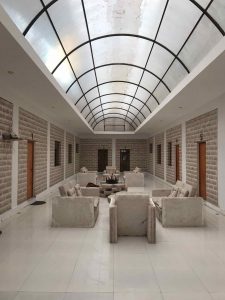
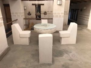
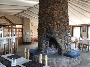
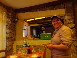
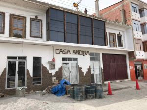 Uyuni is a town focused on the Salt Flat Tours. We are staying at the Hotel de Sal Casa Andina on the eve of our trip. It does not look like much from the outside, but the hotel is a relatively nice one for the area with the rooms and much of the furniture made of the salt! We find the staff at the hotel warm and welcoming.
Sunday – Off to the Flats!
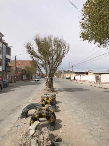
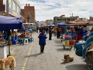 We wake early, prep our bags and have our breakfast at the hotel. I take a quick walk down the dusty main street and through the busy local market that sells everything from clothing to food to household goods. The area seems pretty busy for a Sunday morning.
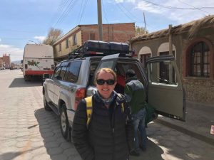
Our guide meets us just before 10 am. We load up our gear into the SUV and we are on our way with our driver and guide. Our guide is Janet, fluent in English and driver is Silvio…not so fluent, lol. I am going to enjoy practicing my fifteen words of Spanish that I know and working to expand on them.
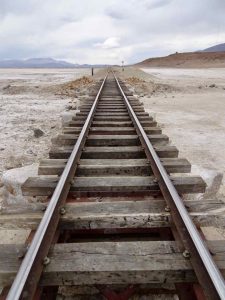
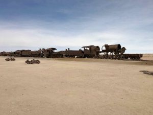 The first stop is the train graveyard, just out-of-town. Trains were used here in the late 1800s through the 1980s in the mining industry. There are still two trains per week on the functional tracks. The town of Uyuni began only because of the train being built in the late 1800s.
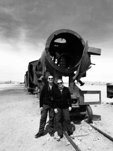
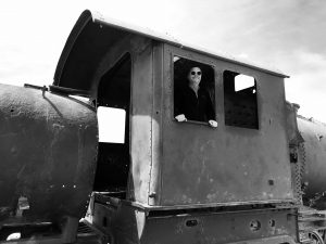
We walk around the area and climb aboard some of the old abandon trains. The tour guides and companies apparently come to the area to clean it up and maintain it a bit since it is an interesting area for tourists to see.
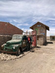
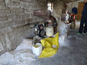 We drive a bit further outside of Uyuni to the small town of Colchani and the salt factory. Colchani is the primary entrance to the salt flats in the area. It’s considered one of the most important communities in the area for having a salt factory with a capacity to extract 20.000 tons of salt per year. No salt is exported. It is mined for human consumption and for building salt hotels for tourists, lol. Ninety percent is for human consumption. We see the rather crude process by which the salt is processed and bagged. We pick up a couple very small bags for souvenirs.
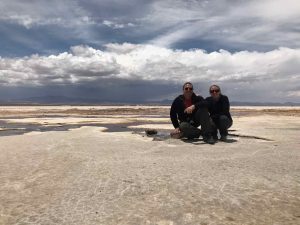
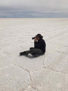 From here, the drive is just a minute or two and we enter the vast salt flats! And I mean vast. For as far as the eye can see all you see is white and a few vehicles driving on them in the distance. In the distance the vehicles look like little bugs running across the horizon.
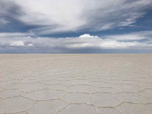 The salt all has a pattern to it that is formed the cracking of the salt. The pattern goes on forever and seems as if it has been formed purposefully. Ahhh, the artwork of Mother Nature.
 We are told that this area was covered by ocean water 40 million years ago. It has produced layers of salt and lakes, eleven of them beneath the surface. The salt is around 120 meters deep at the deepest point. We make a brief stop at some bubbling water. The oxygen in the water below produces a “fizz” that eventually spews bubbles to the surface from the pressure.
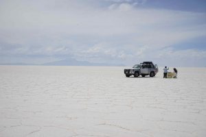
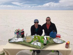
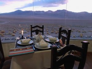
We venture onward across the flats and stop for a private lunch served by our guide and driver. The flats are so vast that it seems you have most of it to yourself.
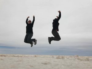
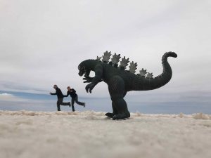 As lunch is being set up, we capture some pictures that are amazing due to the unique perspective this landscape provides. I must say this is the most amazing backdrop I have ever experienced for lunch!
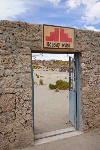
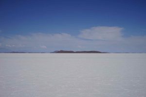 After a bit of wine, food and a few more pics, we drive further into the vastness. Up in the distance we see something on the flats. The closer we get, the larger it gets. We finally come upon Isla Incahuasi, also known as Inca Wasi and Fish Island. It is an “island” among the salt flats. Once covered with water, then an island surrounded by water and now surrounded by salt, it is a hilly, rocky, coral covered outcrop.
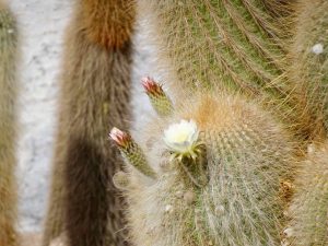
There are unusual coral formations, fossils, large cacti and the remains of an ancient volcano on the 61 acre “island”.
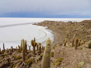
We stop and hike among the trails and hills. It is great place for more incredible perspectives of the salt flats and of course great pictures. It is relatively crowded being one of the few “structures” on this vast plain of salt.
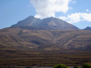
We end the days trekking by driving across the flat to the base of Tahua volcano. The volcano peak is over 6000 meters! Our guide Janet has made the trek up the volcano, but we will not today!
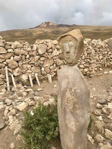
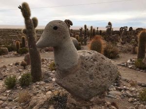 We tour a very small village at the edge of the flats that consists of a couple of generations of only three families. Here we visit a small museum, and an interesting “garden” of coral statues and artwork.
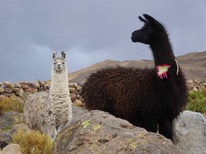 We venture a few more kilometers to Tahua, a small village of several hundred people to our salt hotel, Tahua Salt Hotel. We pass more llama along the way!
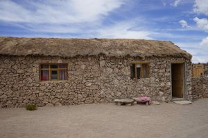
 Our salt hotel is nice. Much of the wood here, particularly the doors are made of cactus wood. It is now illegal to harvest the cactus wood as it grows very slowly here, as slow as a centimeter per year! Some of the cacti we have seen are hundreds of years old. We check in and catch a shower. It is recommended to take the shower early since the water heater is solar-powered.
Our guide joins us for a nice dinner. We start with a cream corn soup followed by grilled chicken, mashed sweet potatoes and a vegetable medley. It is an early evening as more adventure starts early in the morning.
Monday – Day 2 Across the Salt Flats!
Today after a good buffet breakfast, we journey across the salt flats. We stop at Fish Island for a few more pics.
We continue across the flats for some time and eventually come to the end of the salt flats late morning. The edge of the flats has more water near the surface and there seem to be a few designated areas to exit the flats safely.
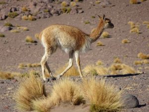
 Once we leave the salt flats we drive across a plain surrounded by old volcanic mountains. We see more llama and vicuna along the way!
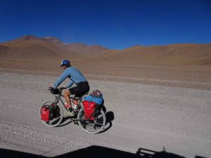
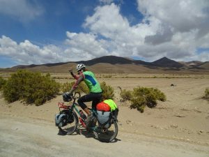 And some crazy bikers! I can’t imagine biking across this incredibly rough, desolate terrain!
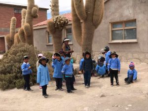 We come upon the small town of San Juan. As we drive through the town we pass by a school with young children that are interested to see us and wave.
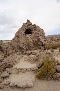 At the edge of the town is a very old cemetery that was used by indigenous people. The dead were buried in “coral tombs” along with various artifacts as well as some precious materials. The tombs were raided during Spanish invasions and valuables stolen.
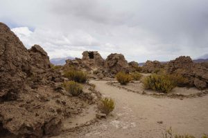
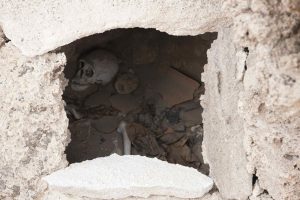 Skulls and bones remain and can be seen through holes and cracks in the coral tombs. It is amazing to think this area was once covered by oceans that left these coral formations.
 We have our picnic lunch in the small “office” adjacent to the cemetery museum. The “picnic” lunch consists of tuna, rice and mixed vegetables.
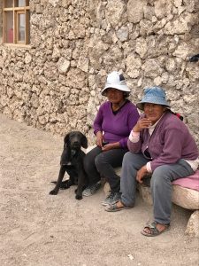
We get to talk to the lady that works at the museum and share our lunch with her. Alejandra is a sweet lady and we all enjoy the conversation. She speaks a local language that our guide does, as well, so the communication works. Unfortunately, she just lost her husband 3 months ago. She loves the photo I took with her. We leave her with some food and drink. She says she is sad to see us go.
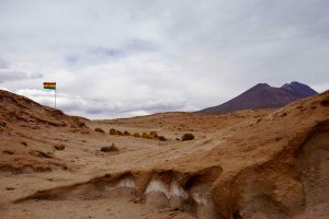
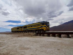 We are close to the Chilean border and there is a small Bolivian military outpost here. There is also a railway that runs through here and we actually see a train come through…two engines.
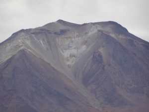 We continue across the small salt flat and into the hills passing many volcanoes, mostly dormant.
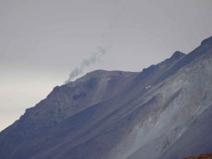 Some are still active and we can see them smoking in the distance such as the Mirador Ollague.
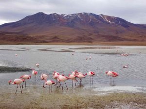
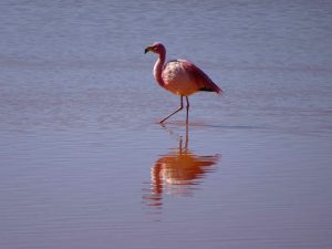
 We visit four lagoons or small lakes. Two of them are filled with pink flamingos. Apparently, the high level of minerals in these lagoons can be digested or processed by the flamingos but is dangerous for humans. We are told it is the algae that the gorgeous flamingo consume that produces their pink color.
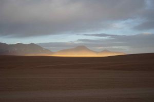
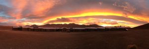 After the last lagoon, we enter a vast desert area with no roads or ways in route to our hotel for the evening. We arrive at the Tayka Desert hotel, 4,500m above sea level (14,663 feet), just in time for a stunning colorful sunset across the plain and mountains.
We have a nice dinner with our guide and driver. It is an early evening as power is cut and lights out at 10 pm!
Day 3 Across the Bolivian Desert into Chile!
 It’s an early start with breakfast at 6 am. The morning light is beautiful and the drive across the volcanic desert with the sun rising is amazing. The desert is vast and in much of the area it seems you just make your own road.
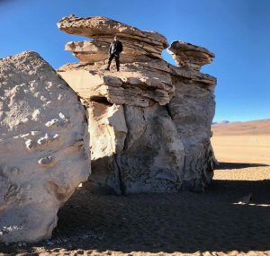
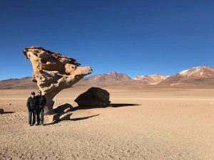 We come across a large grouping of volcanic rocks that have produced beautiful and interesting formations. One is shaped like a tree, the “stone tree”, which is a popular spot for pictures. When I say popular, I mean we happen to see a couple of other vehicles during the visit.
 We journey on to Lake Colorada. Colorada means red (versus “Colorado” which means colorful).
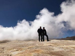
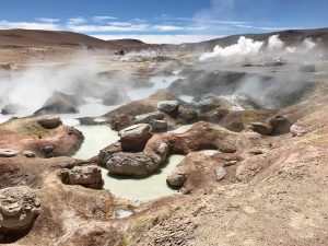 Our next stop is too see the amazing geysers of Sol de Mañana. These are very active and colorful due to the various mineral content.
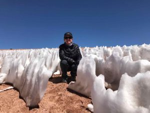 It is cooler here in the higher elevation and snow even remains in the area surrounding these bubbling, steaming pools! The elevation here – 4,962 meters or 16,162 feet! And, of course our bodies are feeling it!
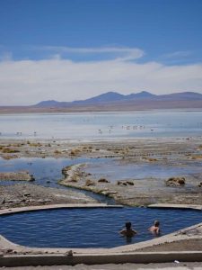 There are hot springs to be visited and experienced, the Polques Hot Springs. The pools are heated “geothermally”. Having our fair share of these in New Zealand and Japan over the past year we don’t make the dip in the pools here.
 We journey onto a portion of the desert called the “Dali Desert”. The area, also called the “Dali Valley”, is named such because the landscapes resemble paintings by Salvador Dali!
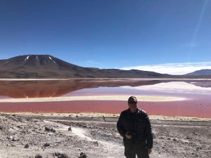
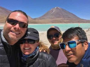
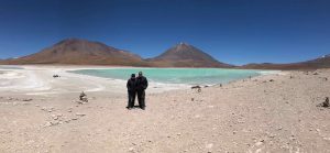 We visit several other lakes in route to the Bolivia – Chile border. The Laguna Verde or “green lagoon” is a beautiful green colored salt lake close to the Chilean border at the foot of the Licancabur volcano. Its color is caused by sediments, containing copper minerals. It is located approx. 4.300 meters (14.000 ft) above sea level.
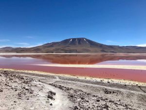
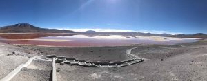 Laguna Colorada is a red colored salt lake, also because of the presence of minerals.
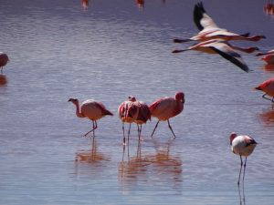
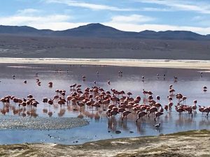 The colorful and plentiful flamingos in these lagoons make for a spectacular scene!
 Our guide and driver prepare our lunch of salad, pasta, chicken and pears for dessert. After lunch, we drive about ten minutes to the Bolivian-Chilean border. We knock on the door of the Bolivia migration office and have our passports stamped. The immigration agent asks us how much we paid for our Bolivian visas at the Bolivian Embassy in Florida. It was $160. Apparently, it is twice that if you do it at the Bolivian border. He said that many people believe they are being scammed at the border. For some reason, he said the embassy on the US discounts it and he is not sure why…but it causes confusion. Anyway, we pass through without a hitch.
 We say our goodbyes to our driver, Silvio, and our guide, Janet. They are both wonderful people and the time we spent with them terrific. Many thanks to the tour company, Ruta Verde.
 The salt flats and deserts of Bolivia should not be missed. They are truly one of the most incredible, stunning sites and scenes of nature we have seen on our travels, arguably one of the most impressive landscapes in the world! This trip is a must do!